When we think about the factors that moved men to explore the confines of the world throughout History, the first idea that comes into our mind is that of human will. The fundamental engine behind any kind of exploration is, undoubtedly, the human nature and the need to satisfy our curiosity, the quest for adventures, immortal glory or, more commonly, the chase of richness. However, there are other major factors, technical and physical that explain how and why the main geographical discoveries happened. One of them is closely related to the rotation of the Earth: the Coriolis Effect.
In mid-November, a new edition of the Atlantic Rally for Cruisers (ARC) will take place. This rally, intended for sailing yachts, could be considered an emulation of the voyages of Columbus in his search for the Indies by sailing westward. There are two possible route choices for the ARC sailors: the first one sails directly from the Canary Islands to the island of Saint Lucia, in the Western Indies, and the second one starts form the same port (Las Palmas de Gran Canaria) but makes a stop in Cape Verde Islands before sailing West (figure 1).
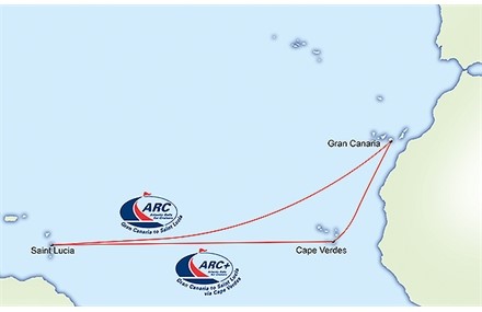
Figure 1: Two options for ARC sailors to reach Santa Lucia: directly from the Canary Islands or via Cape Verde Islands
If we look into a map of Columbus voyages it is easy to recognize on it very similar routes to that of the ARC, especially for the third and fourth voyages of the Admiral (figure 2). Taking into account that Columbus and the ARC sailors share the same means of propulsion in spite of five centuries of time gap, that is, wind and sails, can we conclude that it is a mere coincidence? Definitely not. We are going to see that there exist wind and current patterns in oceanic areas related to the Earth’s rotation that were not empirically discovered until the 15th century by the Portuguese in their Atlantic navigations (of course, these early Portuguese navigators did not have any theoretical or scientific explanation for it).
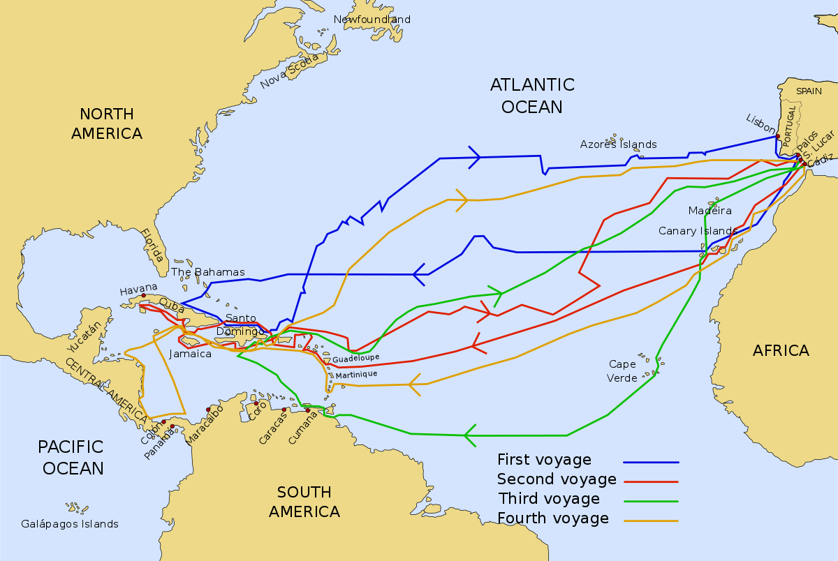
Figure 2: The four voyages of Columbus. Note the similarity with ARC routes, especially in the case of the second, third and fourth voyages
Although there are records of voyages outside the Mediterranean Sea since the times of the Phoenicians (as early as Hanno’s exploration of the western coast of Africa in the 6th or 5th century BC, who could have reached the Gulf of Guinea according to some studies), all of them were examples of coastal navigation. From ancient times, seamen felt the need to keep the coast in sight for obvious safety reasons. The Mediterranean was a well-known, safe and friendly sea but those who dared to navigate across the Fretum Herculeum (Strait of Hercules, the current Strait of Gibraltar) would face the terrible Mare Tenebrosum (Sea of Darkness, the current Atlantic Ocean)) where the conditions at sea changed dramatically and the ocean seemed to be endless. The Pillars of Hercules marked the starting point for all kind of threats and perils (figure 3).
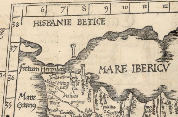
Figure 3: The Pillars of Hercules at the entrance of the Fretum Herculeum (Strait of Gibraltar). Detail from Tabula I Aphricae, in Laurent Fries edition (1522) of Ptolemy’s Geographia. Instituto Geográfico Nacional
It was not until the 15th century when the Portuguese discovered that sailing west into the Atlantic they would find favorable winds to return home from the western coast of Africa. They called it the Volta do Mar (turn of the sea). Ironically, the same wind and oceanic current patterns that had powered Portuguese caravels south to the Gulf of Guinea, would arise as a major obstacle to keep on advancing once they had crossed the equator in their slow progress to reach the Cape of Good Hope. Moreover, after the turning of this cape in 1488 by Bartolomeu Dias, Portuguese fleets departing to reach India in the so called Carreira da India (India Run) begun to apply their knowledge about the Volta do Mar and follow a much longer (in distance) but direct oceanic route that was, in fact, faster than the coastal route, which was slower because of the contrary winds, currents and lack of friendly ports (figure 4). The Volta do Mar consisted basically in sailing powered by the general Atlantic winds and their “parallel” currents in the Atlantic. When Columbus, who arrived at Portugal in 1476, conceived his plan to reach India sailing West, he had already learned from the Portuguese about the “turn of the sea” and other oceanic techniques such as the astronomical navigation in latitude. Thus, he knew he would have backwinds (the trade winds) in his outward route and would have to search further north for favorable winds (the westerlies) to come back to Spain.
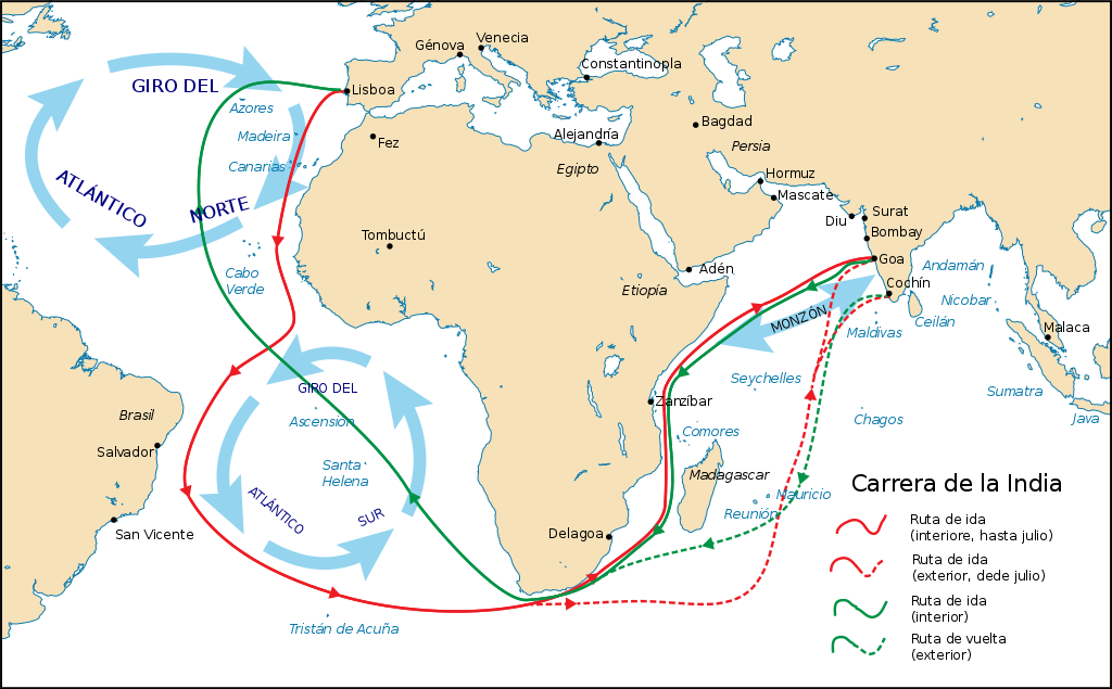
Figure 4: The routes of the Portuguese Carreira da India (India Run) since the end of the 15th century
What neither Columbus nor the Portuguese knew was the scientific reason behind the turn of the sea and winds, clockwise in the northern hemisphere and counterclockwise in the southern one. In 1835, the French mathematician Gaspard-Gustave de Coriolis demonstrated that, when an object moves within a rotating reference system (such as the Earth), an inertial force appears, causing a deflection of the object trajectory to its right if the reference frame rotates counterclockwise and to its left if it rotates clockwise. This is called the Coriolis Effect and it makes winds, ocean currents and, in general, any object moving over the surface of the Earth, to deflect to their right because of the Earth counterclockwise rotation (figure 5).
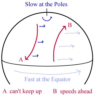
Figure 5: The Coriolis Effect on a counterclockwise rotating Earth causes any moving object to deflect to its right
If the Earth did not rotate, hot air from equatorial regions would ascend and move to the North, where it would get colder and descend to return to the equator (figure 6). But because of the Coriolis Effect, this one cell theoretical model is transformed into a three cell model on each hemisphere that can explain the general wind patterns.
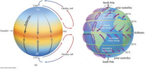
Figure 6: Theoretical atmospheric circulation in a non-rotating Earth (left) and in the actual rotating Earth (right)
Another famous example of the Coriolis Effect, this time on ocean currents, is the Tornaviaje (return voyage) from the Spanish possessions in the East Indies to America. After the first circumnavigation of the World by Magellan and Elcano (1522), Spanish navigators tried to find a return route from the East Indies to America in order to avoid sailing through the Indian Ocean, which was forbidden for them after the Spanish-Portuguese Treaty of Tordesillas (1494) that divided the world in to hemispheres, one for each country (figure 7).
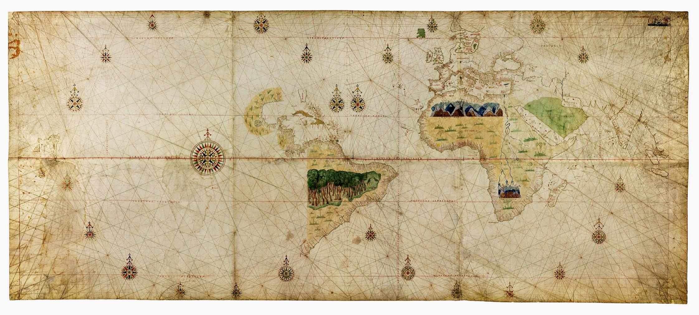
Figure 7: Geocarta Nautica Universale (1523), attributed to Giovanni [Juan] Vespucci. Biblioteca Reale di Torino. The first map to show Magellan and Elcano’s discoveries and the full extension of the Pacific Ocean
After almost 40 years and five Spanish failed attempts, the Tornaviaje was finally found in 1565 by the Spanish cosmographer Andrés de Urdaneta, who intentionally sailed northwest from the Philippines to avoid facing the contrary easterly trade winds, until he reached the 42º latitude and was carried by the Kuro-Shivo current to the shores of Mexico (figure 8).
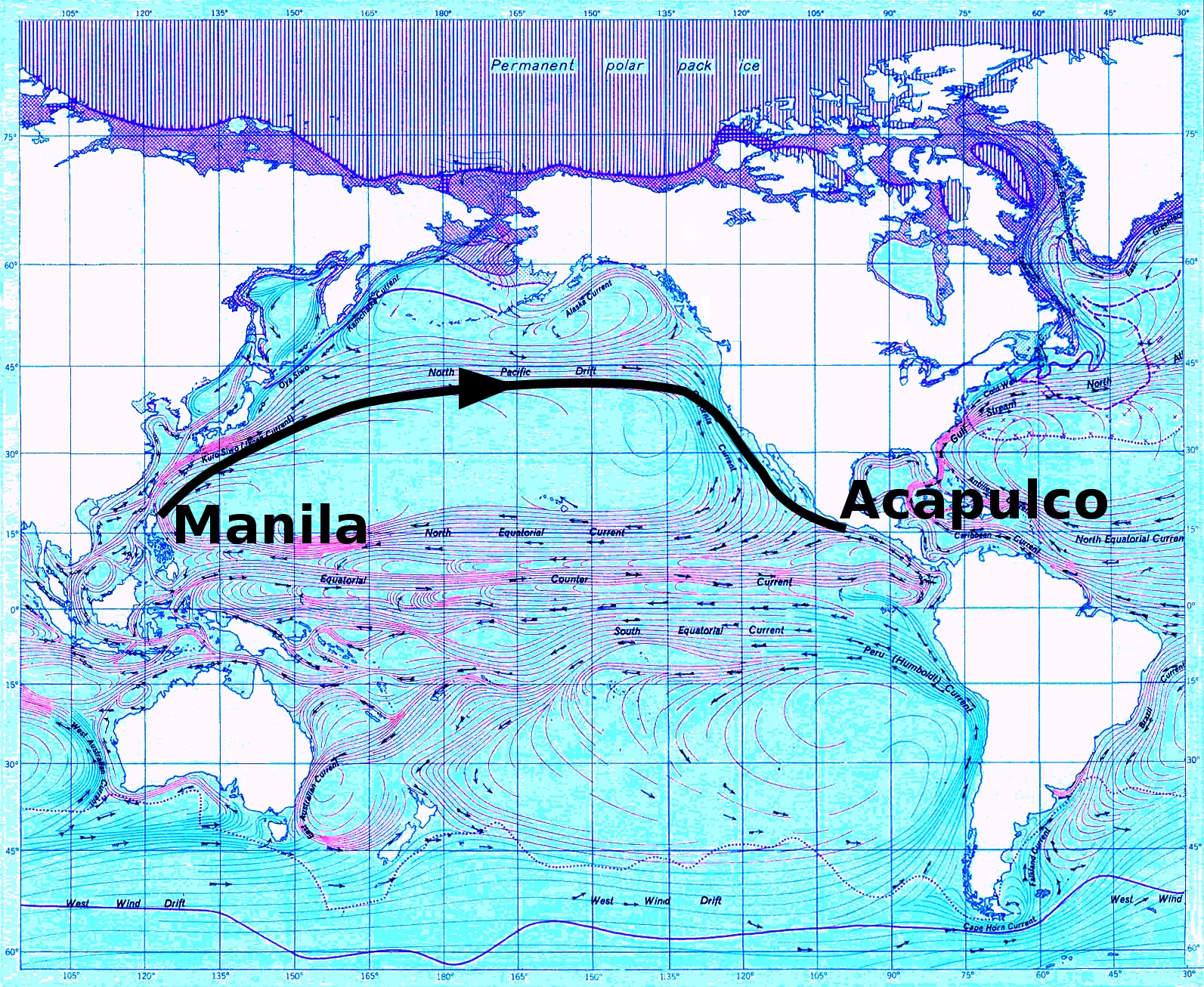
Figure 8: Urdaneta’s Tornaviaje on an ocean currents map
The general patterns of winds and currents on the oceans have reduced their influence on global transport since the introduction of engine propelled vessels and trans-oceanic flights, however, we can find a number of old maps showing the formerly almighty circles of the Coriolis Effect (figure 9).
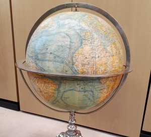
Figure 9: Terrestrial globe displaying ocean currents. Forest, Girard & Barreres, 1927. Paris. Instituto Geográfico Nacional
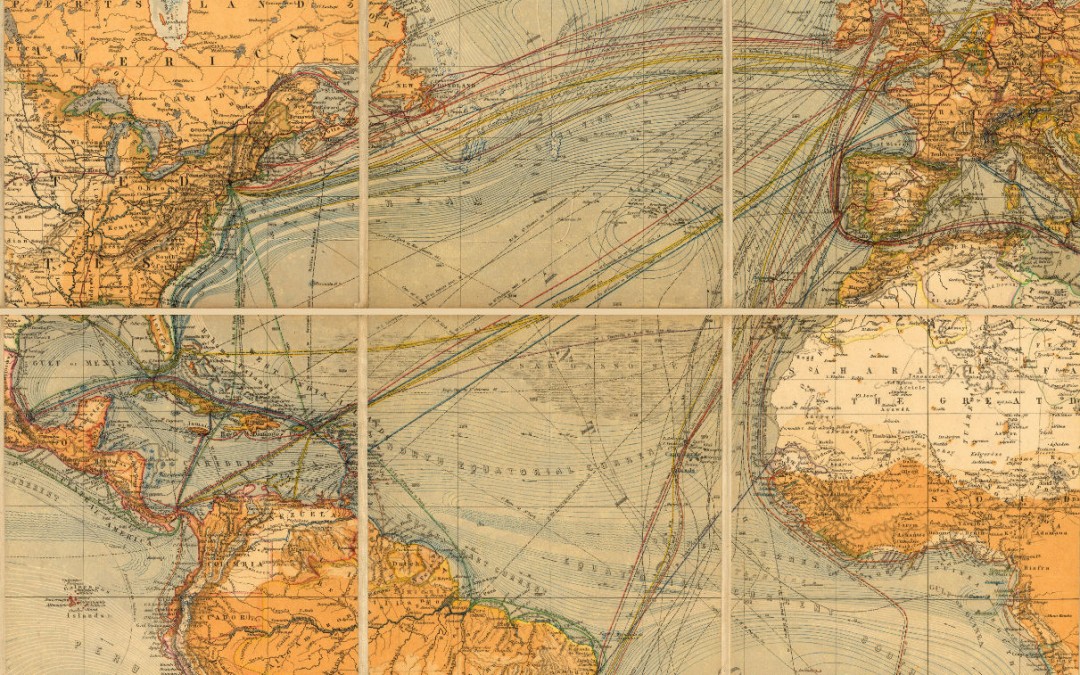
The 19th century map in figure 10, that shows steam and sailing vessels routes all over the world, as well as ocean currents, is a good example of what we could call a “highway map” of the ocean, and it could be used nowadays by the sailors of the Atlantic Rally for Cruisers.

Figure 10: Chart of the world on Mercator’s projection (1871). Hermann Berghaus. Instituto Geográfico Nacional
Marcos Fco. Pavo |
|
 |
Jefe del Área del Registro Central de Cartografía Instituto Geográfico Nacional Ministerio de Fomento |